Functions of GIS
GIScomprises many functions and these functions can be used in variety of applications. The GIS functions facilitate some basic reply those are below.
- The GIS process provides location based information, which helps to locate the particular location of objects. The location can be defined by longitude and latitude or X/Y and this also can have attribute information such as place name etc.
- The GIS functions also support to find the locations under certain conditions such as industries within 5 km from the sewerage treat plant.
- These functions also help to assess the changes on specific location over the time.
- It also supports to analyze the spatial relationship among objects with their geographic locations.
- The functions also provide model based queries, such as optimum path, suitable landfor industry development etc.
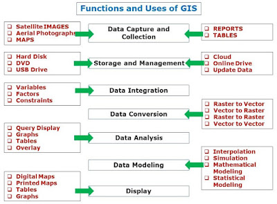
Data Collection and Capture
Remote sensing images, existing maps, tabular data, ground survey, internet etc. are used to collect data as input data to GIS process. These input sources can be used to create digital data through digitization process using GIS software and computer.
Data Storage and Management
Database created through GIS can be stored in to different media such as hard disk, DVD, USB drive, online drive and also on cloud. Spatial database can be updated regularly by acquiring time to time new input sources.
This is most advantageous function as all the data in digital form, therefore to update data is very easy and reduce the data redundancy.
Data Integration
GISmakes it possible to link or integrate information collected from different sources. Thus, GIS can be used in combinations to map variables to create and analyze new variables and factors.
For example, GIS technology, it is possible to combine agricultural records with hydrological data to determine water depth and its physical and chemical quality parameters. This help to understand the water demand and impact of water quality on crop yield.
Data Conversion
It is very important function as it facilitates to analyze data, which are collected from different sources in better way. Such as Jpeg file can be converted into tiff format, conversion of projection to have all data in same projection system through georeferencing.
The data can be converted from raster to vector such as image to polygon/line or vice versa vector to raster such as polygon to raster format. Data can also be converted from raster to raster or vector to vector data as per the need of software and analysis.
Data Analysis
Data can be analyzed by applying appropriate mathematical or statistical algorithms on data to generate new information/maps. It is completely depends on users requirement for example buffer analysis, proximity analysis and interpolation process to create DEM etc.
Data Modeling
The GIS functions allow many simulation models on data to create some useful information for planning such as runoff modeling, urban growth prediction. It also provides tools to create 2D and 3D models of earth surface to assess the feature in better way. For modeling in GIS, many mathematical and statistical methods can be used.
Display
It is the function of presenting results in variety of ways such as digital maps, printed maps, tables and graphs. It is completely depends upon the user’s requirement to display data in different formats.

Nice post! I think Data Collection Automation can be implemented to accelerate GIS processes.
What a very good article. I appreciate your post.We are an vector conversion Company. Recently we have post an article about add brushes to photoshop and Vehicles Background Replacement. Please check out. Thanks
Great job for publishing such a nice article. Your article isn’t only useful but it is additionally really informative. Thank you because you have been willing to share information with us.domain check malaysia
This comment has been removed by the author.