Mapping Through Remote Sensing
Mapping is an important component for management of land resources. Remote sensing datacan be used to create information in the form of mapping of any given area.
Natural features such as such as forest, grass land, water bodies includes river, pond, swamps, ocean, desert areas, mountain/hilly areas etc. can represented with some other feature in the form of mapping.
As well as man-made features, include residential, commercial, industrial and transportation network, combined with administrative boundary can be represented spatially in the form map using satellite images.
As base maps, topographic maps and thematic maps are primary requirement for monitoring, evaluating, planning and management of land resources both manmade and natural.
Elevation maps can be very important in planning and management of many applications such as water resources, forest resources, and large infrastructure.
The Demand of remote sensing images is rapidly growing in production of spatial database. There are many benefits may be achieved by using satellite images such as stereo-coverage (world-view-II), frequent revisit time, wide area coverage and covers globally.
As these data are available in digital format, which facilitate easy storage, updating of data and compatibility with other software/tools for analysis such GIS, SWAT etc.
The base map and topographic maps are key input in many resource companies (mining, oil exploration, forestry), infrastructure development bodies both government and private (DAM & Bridge construction, road construction, telecom etc.) and military.
The application of remote sensing data is much diversified in mapping from military purposes to commercial application as well as for government for resource management.
Mapping in developing countries is in initial stage and need to cover large un-surveyed areas. This mapped information can be used to resolve issues, assess and monitor resources and planning for future developments.
Mapping through remote sensing includes the following
- Base map in the form of thematic maps
- Digital elevation models (DEMs)
- Land Surveying and Mapping
Base map in the form of thematic maps
Digital database created using satellite images in the form of different thematic information are very useful in planning and management of many application.
Therefore, demand of these digital databases of thematic maps is increasing day by day. A base map is prepared using satellite image and digital integration of land use/land cover information and topographic data in the form of contour lines.
This base map can superimpose by relevant thematic maps as well as administrative boundaries as per requirement.
This map information can be used in various combinations with relevant information for many purposes such as land allocation, site selection, route planning, watershed management, monitoring and management of natural resources.
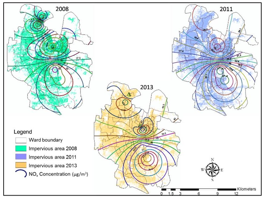
Figure: Builtup layer and NOx concentration Mapped with integration of Administrative boundary
Digital elevation models (DEMs)
Digital elevation models (DEMs) preparation is very significant for mapping different purposes such as land record database, telecom planning, infrastructure planning and water resource management.
Elevation data can be integrated with satellite imagery for generation perspective view (3D view) for better planning and management of projects.

Figure: DEM integrated with satellite imagery for generation perspective view
DEM can be generated by various methods
- Collection elevation data by point data using GPS and after that interpolation method can be used to generate elevation models
- DEM can be generated using remotely sensed data, it is also cost effective and efficient
Integration of DEMs with different thematic maps, increase the accuracy of mapping.
Land Surveying and Mapping
Land surveying and mapping consists of identification of basic land cover featuresfor example forest, drainage and man-made features such as urban infra, transport network and agriculture activities, which is generally used to for urban mapping, facility mapping and crop mapping etc.
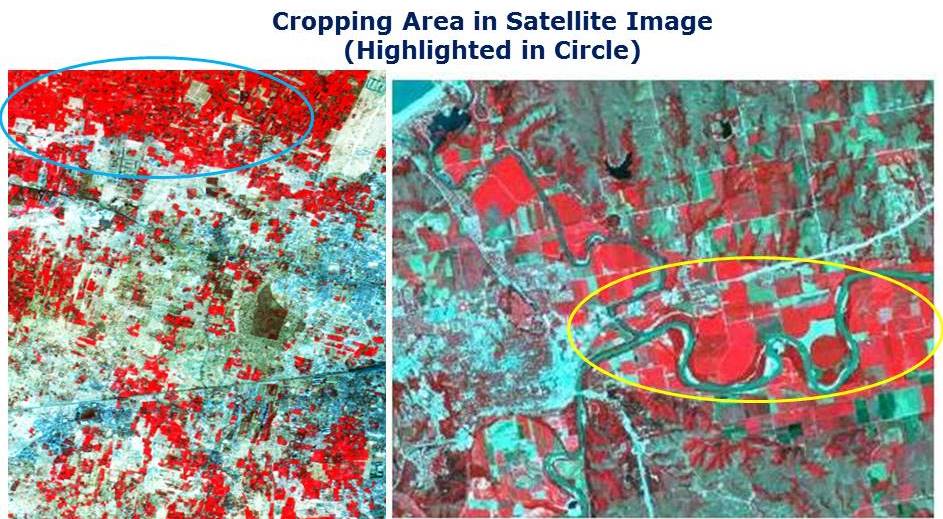
Figure: Crop Mapping Using Satellite Image
Remote sensing facilitate convenient and efficient process for landscape mapping as imagery are available with varying scale (spatial resolution) from high resolution like world view series to low resolution Landsat series. The very high resolution satellite image enhance the accuracy of mapping.
Researching what city your new job is located? Trip-planning apps with mapping show top attractions for your trip. – Save time with routing planner apps – Mapping is easy and reliable – Find top-rated apps
I am really happy to say it’s an interesting post to read. I learned new information about Gps Tracking Solutions Australia from your post, you are doing a great job. Keep it up.