Landscape metrics analysis using classified satellite images to ascertain the urban growth/change pattern…

Urban sprawl is the social process whereby cities grow and societies become more urban. Urbanization is significant all over the world. There are many factors which influence the urbanization like population growth, good prospects for livelihood, good availability of facilities etc.
Mapping from remote sensing techniques has several advantage because it is synoptic, repetitive and multi temporal. Remote sensing technique is also cost effective. Remote sensing images also provides information of change in magnitude, direction and pattern in the urban sprawl.
It is a versatile tool for mapping and monitoring of natural features as well as manmade features. Because of it there is increase in research interest towards the use of remote sensing techniques for urban studies.
Landscape is comprised of spatial patches categorized in different patch classes used for spatial metric calculation. Spatial metrics provide a platform to assess change in land use patterns over time.
Spatial metrics analysis is significant for quantitative characterization of spatial composition and pattern of urban growth. Remote sensing integrated with spatial metrics can provide more efficient and effective spatially reliable information of urban change.
Landscape metrics can be computed as patch-based indices (e.g. size, shape, edge length, patch, density, fractal dimension) or as pixel-based indices (e.g. contagion) to assess growth pattern. The different landscape metrics were computed for classified land use data of Kota City to understand the extent of urban growth and its characteristics.
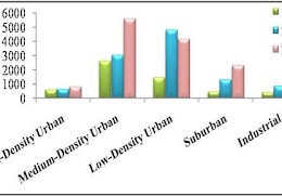
1 Shannon’s Entropy: It value from the classified remotely sensed data can efficiently identify and characterize the urban sprawl. This index ranges from 0 to1, in which 0 indicates the uniformity within the neighborhood, however 1 indicates maximum diversity.

Fig: Shannon’s entropy index for Urban Sprawl