Image Interpretation Elements
As discussed in last article about image interpretation and also defined image interpretation elements/keys.
Elements/Keys are below-

Figure-Use of Elements/Keys for Image Interpretation
- Size
- Shape
- Shadow
- Tone/Color
- Texture
- Pattern
- Height & depth
- Site
- Association
Color
Color is primary element and convenient to identify and recognize earth surface feature on multi band satellite image. Color images can be obtained by combination of three bands and two type of combinations can be prepared, first Natural Color composite (NCC) and the second one is False color composite (FCC).
In both type of combination color may vary for the same feature, such as vegetation appears green in NCC whereas it will appear red in FCC.

Figure- Color variation in FCC and NCC
Tone
It refers to the average brightness of an area or, in the case of color imagery, to the dominant color of the region. It depends on the nature of the surface and illumination. Smooth surfaces behave like specular reflectors, they tend to reflect radiation in a single direction. These features may appear bright or dark.
Whereas Rough surfaces behave as diffuse reflectors and Scatter radiation in all directions. Tone is also very important element for interpretation in panchromatic images (Black and White satellite image).

Figure- Tone variation
Size
Size can be defined as dimension of a feature. The object size is most significant distinguishable characteristic and image element for image interpretation. Size can be represented by absolute size and relative size of object.
- Relative size determined by comparing the object with familiar nearby features. Relative size is important in differentiating between objects.
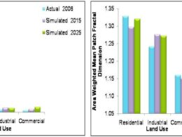
- For example during the interpretation of land use map than differentiating residential, commercial and industrial features becomes very easy by deploying relative size concept as industry and commercial building features are comparatively bigger in size with respect to residential buildings.
- Absolute size refers to derive measurements by using satellite images/aerial photographs. In this process absolute size of object is measured by multiplying length. But accuracy of measurement depends upon the accuracy of geometric correction.
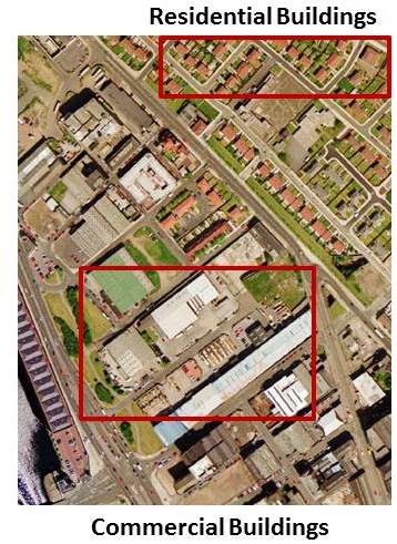
Figure- Showing variation in Size of features
Shape
It can explain as the structure or outline of a feature. The shape of an object is described as the geometric form of object appeared on image.
Shape can be in different regular form such as square, rectangles and circles of man-made features. For this examples can be agriculture fields in rectangle shape, stadium in circle shape etc.
whereas natural features have irregular shape with no distinct pattern visible such as water body, river and forest etc.
It is Important to note that shape depends on perspective and overhead perspective, introduces scale effects.
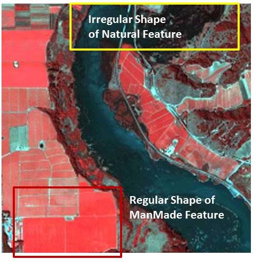
Figure- Type of Feature Shapes
Shadow
It is very important elements as it help to identify object as well as create obstacle for visual image interpretation. Shadow cast by object depends on the nature of the object, angle of illumination, perspective, and slope of the ground surface.
Shadow also gives height information of tall buildings as well as shape details of object. Shadow also helpful in interpretation as it provides information object height and its profile. So it may make identification of feature much easier.
Shadow at same time hide the information as many objects not appeared clearly under the shadow and create problem in identification and reorganization of features.

Figure- Role of Shadow in Image Interpretation
Texture
It states to the variation in tone over a surface or the apparent roughness or smoothness of the surface in an image. Homogeneous surface will appear smooth such as grassland/agriculture whereas non uniform surface will appear rough such as forest area/scattered vegetation.

Figure- Texture variation of rough and smooth
Pattern
Patterns refer to the distinctive arrangement of features. Both man made and natural feature may arrange systematically or randomly on the earth surface. Pattern can help to identify agriculture and urban features, such as Orchards have trees /plant rows and Residential areas/agriculture fields have rectangular rows.
Height and Depth
Relative heights can be used to interpret objects. In a similar way, relative depths can often be interpreted. Height can describe as include tall, intermediate and short; whereas depth can be defined as deep, intermediate, and shallow.
This element facilitate to measure height/elevation and depth of feature, which can be used to identify and discriminate an object.

Figure- Height Element to discriminate objects
Site
Site is important element as it describe feature based on its unique physical or socioeconomic characteristics. Some features occupy a distinctive topographic position because of their function.
Such as sewage treatment facilities at the lowest feasible topographic position and power plants located adjacent to water bodies for cooling.

Figure- Importance of Site Element for Object Recognition
Association
Association refers to the distinctive spatial interrelationships between features such as Schools often associated with athletic fields/ground whereas large parking lots often associated with malls/commercial/industrial/stadium buildings. This is very important when trying to interpret an object or activity.
Association refers to the fact that certain features and activities are almost always related to the presence of certain other features and activities.

Figure- Showing association of features
All the above elements can be used together or in combination to identify and recognize objects in image interpretation process.