What is GPS and How does GPS work? GPS (Global Positioning System) GPS is a satellite-based navigation system used byadminMarch 22, 2025
How to subset a satellite image in ArcGIS? The ability to subset a satellite image to concentrate on a particular area of byadminMarch 4, 2025
How to Change Band combination of satellite image in ArcGIS Use of Band Combination in Satellite Image Processing In satellite image byadminFebruary 24, 2025
Layer Stacking or Band composite of Landsat Satellite data using ArcGIS Integration of numerous spectral bands of Landsat byadminFebruary 17, 2025
Remote Sensing DataSeptember 20, 2020 What are Satellite/Sensor Characteristics Satellite/Sensor Properties for Image Processing This article will bring byadmin
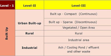
RS AnalysisAugust 14, 2020 HOW TO DETECT CHANGES IN LAND USE LAND COVER CHANGE USING GEO-SPATIAL TECHNOLOGY Remote sensingis used for change detection and analysis of different earth byadmin
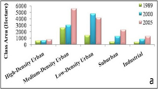
Remote Sensing applicationsAugust 10, 2020 Geo-Spatial Data integrated with Landscape Metrics for Urban Sprawl Pattern Analysis Remote Sensing datacan be applicable in many fields as direct use to assess byadmin
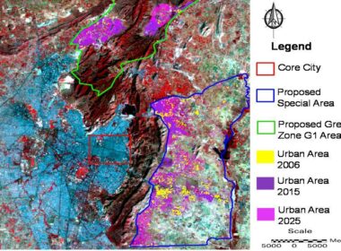
GIS Analysis RS AnalysisAugust 5, 2020 How Geo Spatial Technology used for Scenario Analysis based on Land use Plan and Policies This article is in continuation of last article in which remote sensingand GIS byadmin
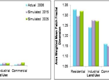
GIS Analysis RS AnalysisAugust 4, 2020 Geo Spatial Technology for Scenario Based Analysis of Future Urban Sprawl/Growth Remote Sensing data or images can be used to assess past trends and current byadmin
GIS Analysis RS AnalysisAugust 1, 2020 Geo-Spatial Technology for Urban Sprawl Projection/Prediction Urban sprawl, an outcome of socioeconomic development and population under byadmin
RS AnalysisJune 10, 2020 Digital Image Processing-Introduction to Image Classification Introduction to Image Classification Classification is a simple process to byadmin
GIS Analysis Remote Sensing applicationsJune 4, 2020 Geo-Spatial Technology for Wetland Mapping Inland Wetland Environment Wetlands refer to lowlands covered with shallow byadmin
GIS Analysis Remote Sensing applicationsMay 28, 2020 Geo-Spatial Technology to Assess Thermal Stress in Coastal Ecosystem Introduction Thermal variations always affect the natural phenomenon whether it byadmin
GIS Analysis Remote Sensing applicationsMay 20, 2020 Geo-Spatial Technology for Groundwater Discharge Monitoring In this article ground water discharge/seepage in to coastal ecosystem is byadmin