What is GPS and How does GPS work? GPS (Global Positioning System) GPS is a satellite-based navigation system used byadminMarch 22, 2025
How to subset a satellite image in ArcGIS? The ability to subset a satellite image to concentrate on a particular area of byadminMarch 4, 2025
How to Change Band combination of satellite image in ArcGIS Use of Band Combination in Satellite Image Processing In satellite image byadminFebruary 24, 2025
Layer Stacking or Band composite of Landsat Satellite data using ArcGIS Integration of numerous spectral bands of Landsat byadminFebruary 17, 2025
GIS Analysis RS AnalysisAugust 7, 2020 How Geo-Spatial Technology used for Spatial Analysis- A Scenario Based Analysis Approach Remote Sensing process is very significant to keep watch on earth surface byadmin
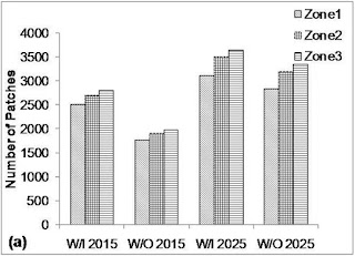
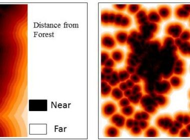
GIS Analysis RS AnalysisAugust 1, 2020 Geo-Spatial Technology for Urban Sprawl Projection/Prediction Urban sprawl, an outcome of socioeconomic development and population under byadmin
GIS IntroductionMay 8, 2020 What are the Functions and Uses of GIS Functions of GIS GIScomprises many functions and these functions can be used in byadmin
GIS Analysis GIS TutorialsMay 4, 2020 How to Create Polygon Features in QGIS Software Polygon Feature creation using QGIS GIS can be used to create spatial data byadmin
GIS Analysis GIS TutorialsApril 13, 2020 Spatial Data Creation using QGIS Software Spatial Data Creation Spatial data can be created using any GIS software, these byadmin
GIS DataApril 11, 2020 What are the Raster Data Formats in GIS and Remote Sensing???? Raster Data Formats used in GIS and Remote Sensing Earth surface features byadmin
RS Analysis RS TutorialsMarch 17, 2020 Digital Image Processing Erdas Tutorial- How to Re-project Satellite Images Re-project Satellite Image This article Shared to understand projection and byadmin
Workshops & TrainingMay 28, 2019 Institute for GIS and Remote Sensing Training Courses GIS is a versatile tool specially for monitoring and planning byadmin
GIS IntroductionMay 27, 2019 What is GIS (Geographical Information System) GIS (Geographical Information System) Geographical Information System (GIS) is byadmin