What is GPS and How does GPS work? GPS (Global Positioning System) GPS is a satellite-based navigation system used byadminMarch 22, 2025
How to subset a satellite image in ArcGIS? The ability to subset a satellite image to concentrate on a particular area of byadminMarch 4, 2025
How to Change Band combination of satellite image in ArcGIS Use of Band Combination in Satellite Image Processing In satellite image byadminFebruary 24, 2025
Layer Stacking or Band composite of Landsat Satellite data using ArcGIS Integration of numerous spectral bands of Landsat byadminFebruary 17, 2025
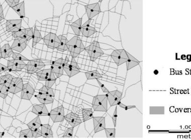
GIS AnalysisAugust 13, 2020 Geo-Spatial Technology for Public Transport Access Analysis Spatial data can be manages and analyzed using GIS byadmin
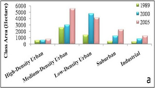
Remote Sensing applicationsAugust 10, 2020 Geo-Spatial Data integrated with Landscape Metrics for Urban Sprawl Pattern Analysis Remote Sensing datacan be applicable in many fields as direct use to assess byadmin
GIS Analysis RS AnalysisAugust 7, 2020 How Geo-Spatial Technology used for Spatial Analysis- A Scenario Based Analysis Approach Remote Sensing process is very significant to keep watch on earth surface byadmin
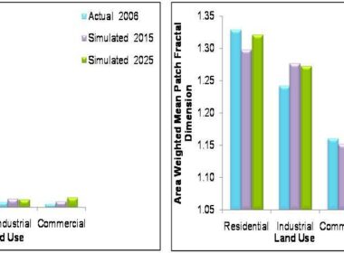
GIS Analysis RS AnalysisAugust 5, 2020 How Geo Spatial Technology used for Scenario Analysis based on Land use Plan and Policies This article is in continuation of last article in which remote sensingand GIS byadmin
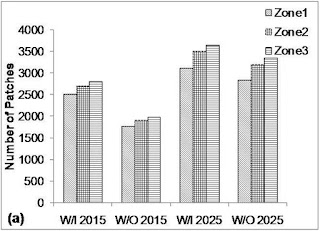
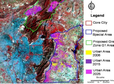
GIS Analysis RS AnalysisAugust 4, 2020 Geo Spatial Technology for Scenario Based Analysis of Future Urban Sprawl/Growth Remote Sensing data or images can be used to assess past trends and current byadmin
GIS AnalysisJuly 29, 2020 Geo-Spatial Analysis-Land Use Mix Spatial Data Analysis Introduction GIS is a versatile tool and can be used for variety of application byadmin
GIS Analysis GIS TutorialsJuly 1, 2020 Buffer Analysis using QGIS Introduction to Buffer Analysis GIS provide many tools for understanding and byadmin
GIS AnalysisMarch 3, 2020 How Geo-spatial Technique used for Drinking Water Quality Analysis The GIStechniques is a best tool to assess and analyze water quality byadmin
GIS AnalysisJune 4, 2019 Geo-Spatial Technology Used for Urban Population Analysis GIS Application for Urban Population Analysis Population density change byadmin
GIS Analysis RS AnalysisAugust 1, 2020 Geo-Spatial Technology for Urban Sprawl Projection/Prediction Urban sprawl, an outcome of socioeconomic development and population under byadmin